
Come join and explore the beautiful Southern Africa,
Namibia, Botswana, Zambia, Zimbabwe and South Africa

Destinations

Namibia
Capital Citry: Windhoek
Area: 825 615 km²
Population: 2,303 millioner (2013
Officiall Language: English
Currency: Namibisk dollar(NAD) and the South African rand (ZAR)
The Republic of Namibia, is a country in southern Africa bordering to the Atlantic Ocean on the westside. Sharing land borders with Zambia, Zimbabwe and Angola to the north, Botswana to the east and South Africa to the south and east. Namibia gained independence from South Africa on the 21st of March 1990, and it is a member state of the United Nations (UN), the Southern African Development Community (SADC), the African Union (AU), and the Commonwealth of Nations.
What to experience in Namibia:
-
Windhoek
-
Waterberg
-
Hoba Meteoret
-
Etosha National Park
-
Damaraland
-
Skeleton Cost
-
Cape Cross
-
Walvis Bay
-
Swakopmund
-
Namib Desert (Sossusvlei)
-
Luderitz (Kolmanskop)
-
Fish River Canyon (Ai Ais)
-
Gobabis/Epukiro
Windhoek (windy corner) capital city and the largest city in Namibia, lies in the senter for the country. Surrounded by the Khomas-Platau around 1 700 meters above sea level. Here you can experience the old colonial and the new modarn arcitect. You can easily walk to most shops, restaurants, clubs and sights.
Waterberg National Park is a national park in central Namibia on the Waterberg Plateau, 68 kilometres south east of Otjiwarongo. The plateau and the national park are named after the table mountain that rises from the plateau, the Waterberg (Water Mountain). The Waterberg Plateau is a elevated high above the plains of the Kalahari of Eastern Namibia. The Park and some 405 square kilometres of surrounding land were eclared a Nature Reserve in 1972. As the plateau is largely inaccessible from beneath several of Namibia's endangered species were relocated in the early 1970s to protect them from predators and poaching to extinction. The programme was very successful and Waterberg now supplies other Namibian parks with rare animals. In 1989, Black Rhinoceros was reintroduced to the area from Damaraland.
The Waterberg Plateau National Park is ecologically diverse and rich and has over 200 different species of bird with some rare species of small antelope on the lower hills of the mountain. Geologically, the oldest rock stratum is over 850 million years old and dinosaurs tracks were left there some 200 million years ago.
The Waterberg area also holds a historical background, where The Hereros were involved in a number of military conflicts with the German colonial forces. One of their most significant events, which also changed the course of the Namibia's History, took place here on the foothills of Waterberg at the turn of the 20th century.
In 1904, the proud Herero people, led by Chief Samuel Maharero, were defeated in their final and most epic battle against the Germans. They were eventually forced from Waterberg and retreated eastward to British Bechuanaland (now Botswana). Thousands were killed by the ensuing Germans and many perished with their cattle in the barren and inhospitable Omaheke plains on the way. Estimates were that nearly two thirds of the Herero population lost their lives during this period.
The Hoba meteorite lies on the farm "Hoba West", not far from Grootfontein, in the Otjozondjupa Region of Namibia. It has been uncovered, but because of its large mass, it has never been moved from where it fell. The main mass is estimated at more than 60 tons, making it the largest known meteorite (as a single piece) and the most massive naturally-occurring piece of iron known on Earth's surface. It as discovered in 1920.


Etosha National Park is a national park in northwestern Namibia. The park was proclaimed Etosha Game Park and was elevated to status of National Park in 1967 by an act of parliament of the Republic of South Africa which administered South-West Africa during that time.
Etosha National Park spans an area of 22,270 square kilometres and gets its name from the large Etosha pan which is almost entirely within the park. The Etosha pan (4,760 square kilometres) covers 23% of the area of the total area of the Etosha National Park. The park is home to hundreds of species of mammals, birds and reptiles, including severalthreatened and endangered species such as the black rhinoceros.
Etosha Game National Park has three accommodations, Okaukuejo on the southwest gate of the park. Stay in bungalows/chalets with views of the breath taking waterhole. Here can see lions, elephants, rhinos and antilops drinking side by side. Braai yourself or dinne in one of Namibias' best restaurants. Halali lies in the center of the park, also known for it wonderful waterhole and bungalows/chalets. Namutoni is on the east gate of the park, known for its' tall white former German fort, built in 1896. The original fort was destroyed in 1904 and rebuilt a year or two later. The current fort was restored to its present state in 1957 and now largely serves as a lodge, stopover, and view point for visitors to Etosha National Park.
Damaraland has Twyfelfontein (jumping waterhole), is a site of ancient rock engravings in the Kunene Region of north-western Namibia. It consists of a spring in a valley flanked by the slopes of a sandstone table mountain that receives very little rainfall and has a wide range of diurnal temperatures.
The site has been inhabited for 6,000 years, first by hunter-gatherers and later by Khoikhoi herders. Both ethnic groups used it as a place of worship and a site to conduct shamanist rituals. In the process of these rituals at least 2,500 items of rock carvings have been created, as well as a few rock paintings. Displaying one of the largest concentrations of rock petroglyphs in Africa, UNESCO approved Twyfelfontein as Namibia's first World Heritage Site in 2007.
The Petrified forest located some 40 kilometres west of the Namibian town of Khorixas, on the C39 road, is a deposit of large tree trunks that have "turned to stone" through a process of diagenesis. There at least two large tree trunks exposed to view and more may be out of sight. The site was declared a National Monument on 1 March 1950.
It is believed that the trees were swept downstream by a large flood and covered by alluvial sands. Deprived of air, the organic matter could not rot and decay, but instead, over millions of years, underwentsilicification, whereby each cell is individually fossilised and the appearance, if not the colour, of wood is retained. The surrounding sands became sandstone, which is now eroding away.
In addition, there are a large number of welwitschia plants at the site.
Public access is by guided tour only. There are toilet and refreshment facilities.
The Brandberg (Omukuruvaro), is Namibia's highest mountain. Brandberg Mountain is located in Damaraland, in the northwestern Namib Desert, near the coast, and covers an area of approximately 650 km². With its highest point, the Königstein, standing at 2,573 m above sea level and located on the flat Namib gravel plains, on a clear day 'The Brandberg' can be seen from a great distance. The nearest settlement is Uis, roughly 30 km from the mountain.
The Brandberg is a spiritual site of great significance to the San (Bushman) tribes. The main tourist attraction is The White Lady rock painting, located on a rock face with other art work, under a small rock overhang, in the Tsisab Ravine at the foot of the mountain. The ravine contains more than 1 000 rock shelters, as well as more than 45 000 rock paintings.
To reach The White Lady it is necessary to hike for about 40 minutes over rough terrain, along the ancientwatercourses threading through the mountain.
The Skeleton Coast is the northern part of the Atlantic Ocean coast of Namibia and south of Angola from the Kunene River south to the Swakop River, although the name is sometimes used to describe the entire Namib Desert coast. The Bushmen of the Namibian interior called the region "The Land God Made in Anger", while Portuguese sailors once referred to it as "The Gates of Hell".
The name Skeleton Coast was invented by John Henry Marsh as the title for the book he wrote chronicling the shipwreck of the Dunedin Star. Since the book was first published in 1944 it has become so well known that the coast is now generally referred to as Skeleton Coast and is given that as its official name on most maps today.
On the coast the upwelling of the cold Benguela current gives rise to dense ocean fogs (called "cassimbo" by the Angolans) for much of the year. The winds blow from land to sea, rainfall rarely exceeds 10 millimetres (0.39 in) annually and the climate is highly inhospitable. There is a constant, heavy surf on the beaches. In the days of human-powered boats it was possible to get ashore through the surf but impossible to launch from the shore. The only way out was by going through a marsh hundreds of miles long and only accessible via a hot and arid desert.
The coast is largely soft sand occasionally interrupted by rocky outcrops. The southern section consists of gravel plains while north of Terrace Bay the landscape is dominated by high sand dunes. Skeleton Bay is now known as a great location for surfing.
Cape Cross is a small headland in the South Atlantic in Skeleton Coast, western Namibia, on the C34 highway some 60 kilometres north of Hentiesbaai and 120 km north of Swakopmund on the west coast of Namibia. Today Cape Cross is a protected area owned by the government of Namibia under the name Cape Cross Seal Reserve. The reserve is the home of one of the largest colonies of Cape fur seals in the world.
Walvis Bay, Ezorongondo, ("Whale Bay") is a city in Namibia and the name of the bay on which it lies. The town has 100,000 inhabitants and covers a total area of 29 square kilometres of land.
The bay is a safe haven for sea vessels because of its natural deepwater harbour, protected by the Pelican Point sand spit, being the only natural harbour of any size along the country's coast. Being rich in plankton and marine life, these waters also drew large numbers of Southern right whales, attracting whalers and fishing vessels.


Swakopmund ("Mouth of the Swakop") is a city on the coast of western Namibia, 280 km (170 mi) west of Windhoek. The town has 44,725 inhabitants and covers 193 square kilometres of land. The city is situated in the Namib desert and is the fourth largest population centre in Namibia.
Swakopmund is a beach resort and an example of German colonialarchitecture. It was founded in 1892 as the main harbour for German South-West Africa, and a small part of its population is still German-speaking today.
Buildings in the city include the Altes Gefängnis prison, designed by Heinrich Bause in 1909. The Woermannhaus, built in 1906 with a prominent tower, is now a public library. Attractions in Swakopmund include a Swakopmund Museum, the National Marine Aquarium, a Crystal Gallery and spectacular sand dunes near Langstrand south of the Swakop River. Outside of the city, the Rossmund Desert Golf Course is one of only five all-grass desert golf courses in the world. Nearby lies a camel farm and the Martin Luther steam locomotive, dating from 1896 and abandoned in the desert.
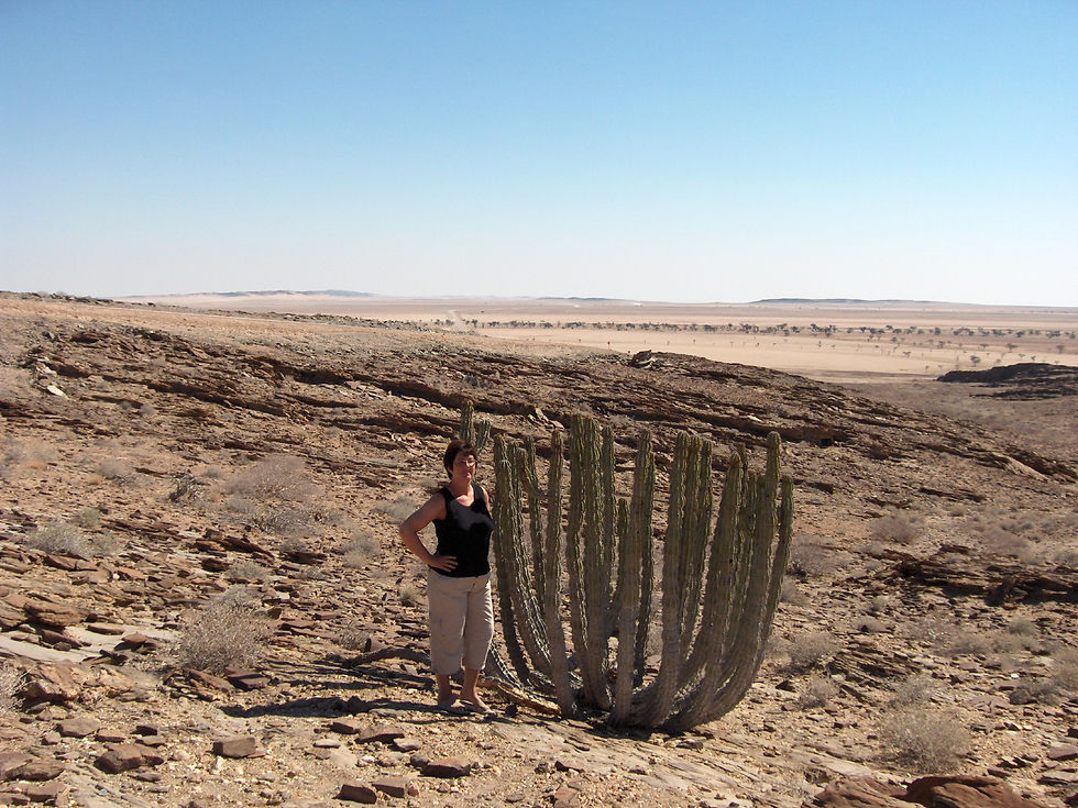
The Namib Desert is considered the oldest desert in the world. The name Namib is of Nama origin and means "vast place".
The Namib-Naukluft National Park is a national park of Namibia encompassing part of the Namib Desert and the Naukluft mountain range. With an overall area of 49,768 km2 (19,216 sq mi), the Namib-Naukluft is the largest game park in Africa and the fourth largest in the world. The most well-known area of the park is Sossusvlei, which is the main visitor attraction in Namibia.
The winds that bring in the fog are also responsible for creating the park’s towering sand dunes, whose burnt orange color is a sign of their age. The orange color develops over time asiron in the sand isoxidized, like rusty metal; the older the dune, the brighter the color.
These dunes are the tallest in the world, in places rising more than 300 meters above the desert floor. The dunes taper off near the coast, and lagoons, wetlands, and mudflats located along the shore attract hundreds of thousands of birds.
Lüderitz is a harbour town in southwest Namibia, lying on one of the least hospitable coasts in Africa. It is a port developed around Robert Harbour and Shark Island.
The town is known for its colonial architecture, including some Art Nouveau work, and for wildlife including seals, penguins,flamingos and ostriches. It is also home to a museum, and lies at the end of a currently decommissioned railway line to Keetmanshoop.
Kolmanskop is a ghost town in the Namib desert in southern Namibia, 10 kilometres inland from the port town of Lüderitz. It was named after a transport driver named Johnny Coleman who, during a sand storm, abandoned his ox wagon on a small incline opposite the settlement. Once a small but very rich mining village, it is now a popular tourist destination run by the joint firm NamDeb(Namibia-De Beers).
Driven by the enormous wealth of the first diamond miners, the residents built the village in the architectural style of a German town, with amenities and institutions including a hospital, ballroom, power station, school, skittle-alley,theatre and sport-hall, casino, ice factory and the first x-ray-station in the southern hemisphere, as well as the first tram in Africa. It had a railway link to Lüderitz.
The town declined after World War I when the diamond-field slowly exhausted and was ultimately abandoned in 1954. The geological forces of the desert mean that tourists now walk through houses knee-deep in sand. Kolmanskop is popular with photographers for its settings of the desert sands' reclaiming this once-thriving town. Due to its location within the restricted area (Sperrgebiet) of the Namib desert, tourists need a permit to enter the town. Permits can be bought at the gate into the town and tours run daily at 9:30am and 11am local time(GMT+2), 10am on a Sunday.
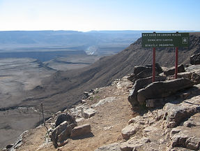
The Fish River Canyon is located in the south of Namibia. It is the largest canyon in Africa, as well as the second most visited tourist attraction in Namibia. It features a gigantic ravine, in total about 160 km long, up to 27 km wide and in places almost 550 meters deep. At the lower end of the Fish River Canyon, the hot springs resort of Ai-Ais is situated.
The Fish River Canyon hiking trail is one of the more popular hiking trails in Southern Africa. The immense scale and rugged terrain has drawn many visitors from all over the world to experience what hiking or trail running the canyon can offer.
Apart from the 2 kilometre descent west of Hobas and some optional short cuts, the trail generally follows 88 kilometres of the Fish River through to Ai Ais and is usually completed within 5 days. Although there are a number of footpaths through the canyon, the trail is not fixed leaving the hiker to decide where and how long to hike.
There are no amenities on the trail and hikers have to carry all their needs with them. Open fires are not allowed on the trail.
Ai-Ais Hot Springs meaning 'burning water' in the local Nama language, refers to the sulphurous thermal hot water springs found in the area. Pronounced "eye-ice", the natural hot-spring oasis is situated at the base of the mountain peaks at the southern end of Fish River Canyon, in the Karas Region of southern Namibia and forms part of the Ai-Ais/Richtersveld Transfrontier Park. The springs are a popular holiday destination for Namibian, South African and international holiday-makers. The thermal waters are rich in sulphur, chloride and fluoride, and are reputedly good for anyone suffering from rheumatism. The resort waters are also home to a number of species of fish, including yellow fish and barbel. Ai-Ais is closed over the summer months from November to mid-March.
Gobabis, Epako, is a city in eastern Namibia. It is the regional capital of the Omaheke Region, and the district capital of the Gobabis electoral constituency. Gobabis is situated 200 km down the B6 motorway from Windhoek to Botswana. The town is 113 km from the Buitepos border post with Botswana, and serves as an important link to South Africa on the tarred Trans-Kalahari Highway. Gobabis is in the heart of the cattlefarming area. In fact Gobabis is so proud of its cattle farming that a statue of a large Brahman bull with the inscription "Cattle Country" greets visitors to the town.
Epukiro, Hereroland, is inhabited by Tswana, Ovambanderu, Ovaherero, and San people. The Herero and Namaqua War of 1904–1907 saw tens of thousands of Ovaherero killed, almost its entire population. Survivors had lost their land and cattle, and the land originally in the hands of the Herero was now farmland in the possession of white settlers.


Botswana
Capital City: Gaborone
Population: 2 219 937
Area: 581 730 km²
Officiall language: Engelsk
Religion: Lokale religioner, protestantisk og katolsk kristendom
National Day: 30. september
President: Seretse Khama Ian Khama
Currency: Pula à 100 thebe (BWP)
What to experience in Botswana:
-
Okvango Delta

The Republic of Botswana , is a landlocked country located in Southern Africa. Bordering South Africa in the south, Namibia to the west and north, and Zimbabwe to the east. Botswana has also a short limit of around 150 meters against Zambia in the north.
The name comes from the largest ethnic group in the country, who are Batswana (or Tswana). The national anthem is "Fatshe leno la rona" ("Bless this noble land").
Okavango Delta is one of the largest inland deltas, the scale and magnificence of the Okavango Delta helped it secure a position as one of the Seven Natural Wonders of Africa, which were officially declared on February 11, 2013 in Arusha, Tanzania. On 22 June 2014, the Okavango Delta became the 1000th site to be officially inscribed on the UNESCO World Heritage Listand.
Every year runs 11 cubic kilometers of water from the Okavango River into the delta, covering an area of 15 000 sq. Nothing of the water runs into the sea , but gets sucked up by plants, evaporates or seeps down as groundwater. The water supply makes the Okavango Delta a very rich flora and fauna , despite the fact that it is located in an area with little rainfall . Even in the Kalahari desert grows enough panther to maintain a diverse wildlife. Botswana has 2500 different plant species. 164 mammals, 593 bird species and a variety of reptiles and insects. National bird is cattle egret. Some flood-waters drain into Lake Ngami. The Moremi Game Reserve, a National Park, is on the eastern side of the Delta.
Zimbabwe
Population: 14,15 millioner (2013)Verdensbanken
Currency: American dollar, Euro, Pula, Britisk pund, Renminbi, Indisk rupi, South African rand
What to experience in Zimbabwe:
-
Victoria Falls

The Republic of Zimbabwe, formerly Southern Rhodesia, Rhodesia and Zimbabwe Rhodesia, is a republic in southern Africa. Zimbabwe borders on Zambia, Mozambique, South Africa and Botswana. The name Zimbabwe is derived from ruins located in the country, from a culture that existed in the Middle Ages. The ruins called Great Zimbabwe.
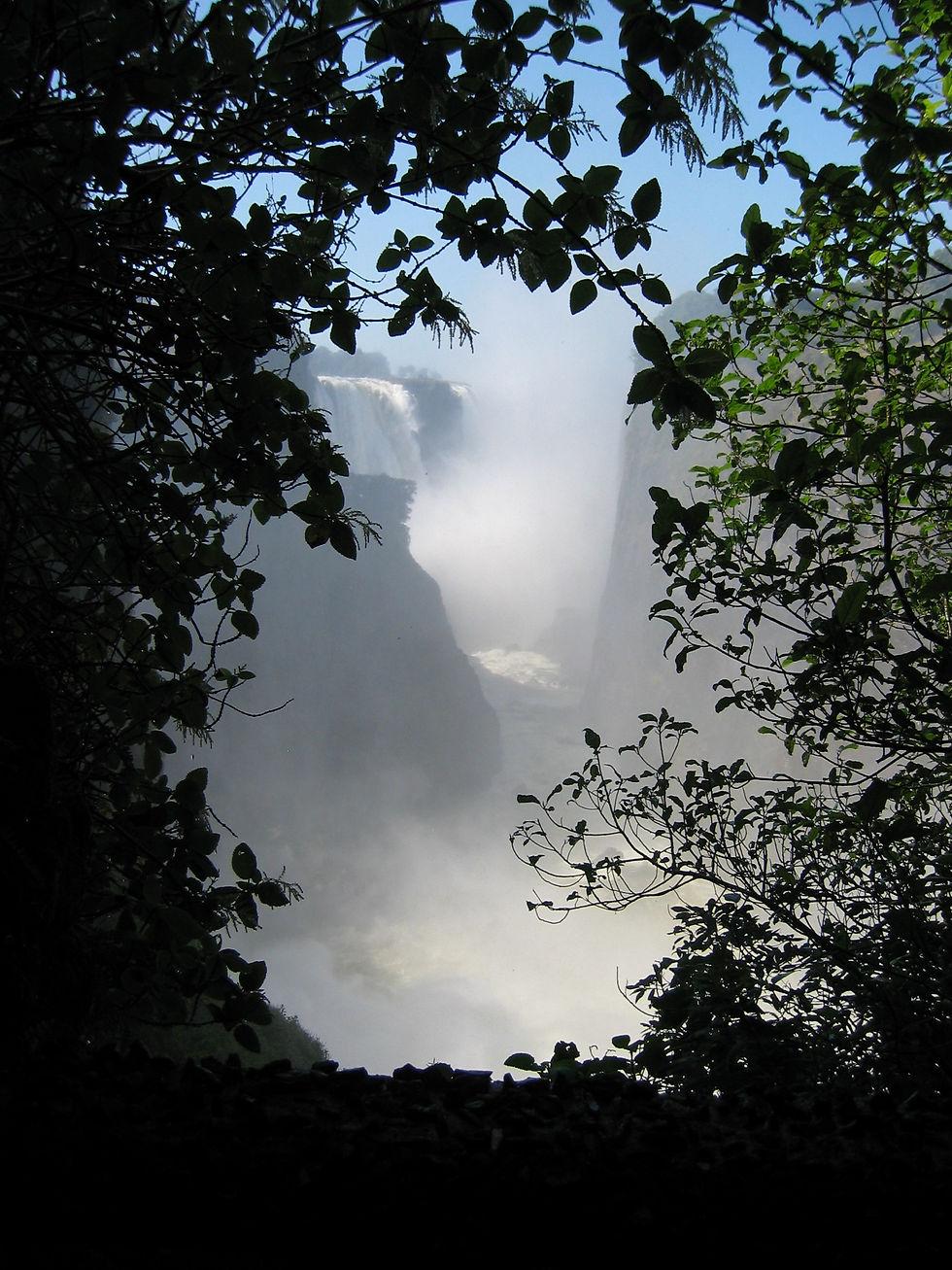
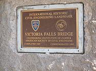
Zimbabwe is surrounded by South Africa to the south, Botswana to the west, Zambia in northwest og Mosambique in east and northeast and has no coastline. The northwestern border is defined av Zambezi-River. Victoria Falls is a popular tourist destination on the Zambezi. In the south, Zimbabwe separated from South Africa by Limpopo. Zimbabwe also shares a short border with Namibia west via a narrow land corridor.
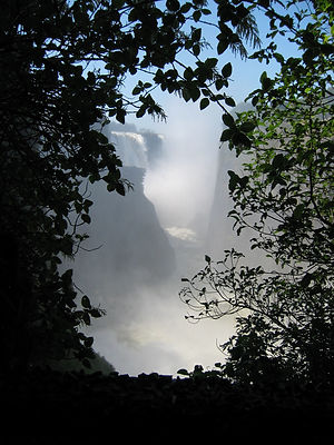
Victoria Falls is a waterfall formed by the Zambezi River. Mosi-oa-Tunya is the name in local language Lozi, which means "The Smoke That Thunders." Highest drop is 108 meters. The waterfall is at its greatest when rain-season finish in March/April. The waterfall is on the border between the countries Zambia and Zimbabwe. The first European who saw the waterfall was explorer David Livingstone in 1855. He named it after Queen Victoria of Britain.


South Africa
Capital Cities: Pretoria, Cape Town,Bloemfontein
Currency: Sørafrikansk rand
Population: 52,98 millioner
Officiall language: English, Afrikaans, Xhosa, Zulu, Sesotho, Tswana, Nordsotho, Tshivenda, Tsonga, Swati, Sørndebele
What to experience in South Africa:
-
Cape Town
-
Table Mountain
-
Robben Island
The Republic of South Africa, is the southern most sovereign state in Africa. It is bounded on the south by 2,798 kilometers of coastline of Southern Africa stretching along the South Atlantic and Indian Oceans, on the north by the neighbouring countries of Namibia, Botswana and Zimbabwe, and on the east by Mozambique and Swaziland, and surrounding the kingdom of Lesotho. South Africa is the 25th-largest country in the world by land area, and with close to 53 million people, is the world's 24th-most populous nation. It is the southern most country on the mainland of the Old World or the Eastern Hemisphere.
South Africa is a multiethnic society encompassing a wide variety of cultures, languages, and religions. Its pluralistic makeup is reflected in the constitution's recognition of 11 official languages, which is among the highest number of any country in the world. Two of these languages are of European origin: Afrikaans developed from Dutch and serves as the first language of most white and coloured South Africans; English reflects the legacy of British colonialism, and is commonly used in public and commercial life, though it is fourth-ranked as a spoken first language. South Africa is often referred to as the "Rainbow Nation" to describe the country's newly developing multicultural diversity in the wake of segregationist apartheid ideology.
Cape Town is a coastal city in South Africa. It is the second most populous urban area in South Africa, after Johannesburg. It is also the provincial capital and primate city of the Western Cape. The city is famous for its harbour, for its natural setting in the Cape Floristic Region, as well as for such well-known landmarks as Table Mountain and Cape Point.
Table Mountain,(Tafelberg) is a flat-topped mountain forming a prominent landmark overlooking the city of Cape Town in South Africa, and is featured in the Flag of Cape Town and other local government insignia. It is a significant tourist attraction, with many visitors using the cableway or hiking to the top. The mountain forms part of the Table Mountain National Park. The main feature of Table Mountain is the level plateau approximately 3 kilometres from side to side, edged by impressive cliffs. The plateau, flanked by Devil's Peak to the east and by Lion's Head to the west, forms a dramatic backdrop to Cape Town.
Robben Island (Robbeneiland) is an island in Table Bay, 6.9 km west of the coast of
Bloubergstrand, Cape Town, South Africa. The name is Dutch for "seal island." Robben Island is roughly oval in shape, 3.3 km long north-south, and 1.9 km wide, with an area of 5.07 km². It is flat and only a few metres above sea level, as a result of an ancient erosion event. Nobel
Laureate and former President of South Africa Nelson Mandela was imprisoned there for 18 of the 27 years he served behind bars before the fall of apartheid. To date, three of the former inmates of Robben Island have gone on to become President of South Africa: Nelson Mandela, Kgalema Motlanthe, and current President Jacob Zuma.
Robben Island is both a South African National Heritage Site as well as a UNESCO World Heritage Site.
South Africa is a big country, and therefor so much more to experience:
- Johannesburg
-
Soweto Township
-
Apartheid Museum
-
Constitution Hill
- Kruger National Park
- Durban
- Drakensberg
- South Africa Wine Region,
-
Stellenbosch
-
Paarl
-
Franschhoek
- Blyde Rue Canyon and Panorama Route
- Cape Paninsula